
 Jason Weingart
Texas Hill Country News
Strong to Severe Storms Possible This Afternoon and Evening Across the Hill Country. Here’s What You Need to Know.
Starting today, a pattern change is in the works for our Central Texas weather. A cold front will bring a chance of strong to severe thunderstorms to the area this afternoon and evening. Storms may grow upscale and consolidate into a mesoscale convective system, bringing the threat for gusty winds, large hail, lightning and heavy rain. Many locations will receive rainfall totals of two to four inches, but some spots could see near seven inches by Tuesday morning if storms train over the same areas.
Simulated reflectivity shows strong storms ongoing in the northern and western portions of the Hill Country at 4:00 p.m.

Photo: Pivotal Weather/HRRR
The Storm Prediction Center has most of the area including the I-35 corridor in a slight risk for severe weather. According to the National Weather Service in Austin/San Antonio, the tornado threat is low but the flood threat is elevated. There will likely be a flash flood watch issued today.
By 7:00 p.m., an organized cluster of storms should be impacting the I-35 corridor.

Photo: Pivotal Weather/HRRR
The flood threat should be greatest during this time as the system slowly moves southward. Floods are the number one weather-related killer of Texans. In our state, more die from floods than all other weather hazards combined. Remember, Turn Around, Don’t Drown. Do not attempt to cross a flooded roadway. Six inches of moving water can sweep a vehicle away.
Storms slowly push south through the night and should begin to clear the I-35 corridor by 10:00 p.m.
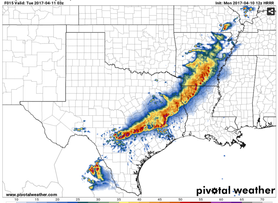
Photo: Pivotal Weather/HRRR
There will be a chance of storms each day this week. Stay tuned to your local National Weather Service and media outlets for the latest. You can watch a live stream of storms this evening on JasonRWeingart.com.
